Third, you need to ‘own the code’ even if the AI produced it. Don’t think that because AI produced the code it’s not yours. The AI tool doesn’t care (or know) about the intention of the code it is producing on your behalf. Even though you didn’t write it, the code is yours in the sense that it is doing (or is trying to do) what you want it to do. As a human it seems intuitive that the AI should understand the code given that it produced it, but it really doesn’t. I found that only by accepting that the code was mine, including any errors in it, could I properly interrogate it to check for errors. But also, if I’m going to use the code for any practical purpose, then it’s my name against the outcomes, so the sooner I take ownership the better.
(more…)
Comments on Kenya’s Wildlife Bill 2025
While in Kenya for our workshop on Integrated Fire Management in Tsavo, we discussed the draft of the Wildlife Conservation and Management Bill 2025 [pdf]. We realised that wildfire or landscape fire was mentioned only very briefly (restricted to a single statement in one clause) and not in way that seemed to meet with the principles and values laid out in the Preliminary section of the Bill (namely adoption of the use of emerging science and indigenous (traditional) knowledge, participatory and inclusive management and an ecosystem approach). Given that these were topics of discussion in our workshop, and that public consultation on the Bill was ongoing, we felt that we could offer some comments on how the Bill might be improved to better reflect those values (as well as our own).
Below are our comments that we submitted via the Ministry of Tourism and Wildlife’s public participation feedback tool.
(more…)Integrated Fire Management in Tsavo, Kenya

“Have you been to Voi before?”
“Yes, although I don’t remember the first time, as I was only two years old”
So went the conversation several times during my visit last week to southern Kenya. I was there as part of our King’s ESRC Impact Accelerator Award project on integrating Indigenous and local community knowledge into fire management. This trip will be much easier to remember.
(more…)Scoping Urban Hazards in Kenya and Malawi
Technically I had been to Nairobi before our last trip last month, so I replied yes when people there asked. But then I told them it was when I was two years old and they laughed about how that didn’t count – partly because I can’t remember a thing from that time and partly because the city has changed so much. Back in 1982, the population of the city was around 900,000 but today it is over 3 million, and possibly up nearer 4 million during the day as people come into the city to work.
I was in Nairobi with colleagues Bruce Malamud and Faith Taylor on an initial research trip for our work on the physical dimensions of hazards in urban areas of Africa. During a meeting on the trip at Mzuzu University near another of our study sites – Karonga in Malawi – someone asked why we were focusing on hazards in urban areas particularly. The answer is partly because of the growth exemplified by Nairobi; Africa is urbanising rapidly and estimates are that 56% of the population of African will be urban by the middle of the century.
(more…)Traditional Fire Knowledge in Spain
When you haven’t done something for a while it’s often best not to rush straight back in at the intensity you were at before. So here’s a nice easy blog to get me going again (not that I was blogging intensely before!).
I didn’t blog about it at the time (unsurprisingly), but back in late June 2013 I went to visit a colleague of mine in Madrid, Dr Francisco Seijo. Francisco and I met back at something I did blog about, the 2009 US-IALE conference in Snowbird. Since then we’ve been discussing how we can use the idea of coupled-human and natural systems to investigate Mediterranean landscapes.
After a brief field visit by me, an interview campaign by Francisco, collection of secondary data from other sources (aerial photography and official fire statistics) and some desk analysis, we recently published our first paper on the work. Entitled Forgetting fire: Traditional fire knowledge in two chestnut forest ecosystems of the Iberian Peninsula and its implications for European fire management policy, and published in the journal Land Use Policy, the article presents the results of our mixed-methods and interdisciplinary approach. Building on Francisco’s previous examination of ‘pre-industrial anthropogenic fire regimes’ we to to investigate differences between the fire regimes and management approaches of chestnut forest ecosystems in two municipalities in central Spain. In the paper we also discuss ideas of Traditional Ecological Knowledge (TEK), the related idea of Traditional Fire Knowledge (TFK), and discuss them in light of contemporary fire management approaches in Europe.
The full abstract is below with links to the paper. I’ll stop here now as this rate of blogging it making me quite dizzy (but hopefully I’ll be back for more soon).
—-
Seijo, Francisco, James DA Millington, Robert Gray, Verónica Sanz, Jorge Lozano, Francisco García-Serrano, Gabriel Sangüesa-Barreda, and Jesús Julio Camarero (2015) Forgetting fire: Traditional fire knowledge in two chestnut forest ecosystems of the Iberian Peninsula and its implications for European fire management policy. Land Use Policy 47 130-144. doi: 10.1016/j.landusepol.2015.03.006
[Online] [Pre-print]
Abstract
Morocco Fieldtrip Recon
I spent a couple of weeks this month in Morocco, the majority of which was scouting out a route for a new physical geography fieldtrip for second year undergraduates at King’s College London. For the last several years the physical geography fieldtrip has been based on the Morocco coast at Agadir and Essaouira, visiting nearby sites. The new fieldtrip will take more of a transect approach, starting in Marrakech, traversing the High Atlas mountains and following the River Draa out to the edge of the Sahara (see map below).
As we work our way up and through the High Atlas one of the things we’ll consider is how vegetation changes and what might be driving those changes. In the picture below you can see colleagues on the trip Prof. Drake and Dr Chadwick (@DrMChad) debating (and betting on!) vegetation on the hills over-looking the town of Demnate.
For example, what are the relative influences of climate and human activity on the vegetation we see? In the picture below Prof Drake confronts one potential disturbance.
As this is a new trip and we’ll be staying in a new location each night, one of our tasks was to check the accommodation we’ll be staying in. Here hotel connoisseurs Drake and Chadwick relax in luxury in the gîte at Toufghine.
There’s some impressive geology in the High Atlas and we’ll discuss that as we go too. The scale of some of the tectonic features is illustrated by Prof Drake in the bottom right of the picture below.
We’ll also be surveying rivers, both their geomorphology and ecology. Another of our tasks therefore was to work out what we would examine and where along the various rivers in the region.
Once we get over the High Atlas and the Anti-Atlas beyond we’ll follow the River Draa all the way to the desert. The Draa is a vital life-line for people in the region, with water drawn from the river used to irrigate agriculture (including wheat).
Once the water has all been used up we reach the desert. There we’ll look for evidence of previous flows of the Draa and of climate change. Some of the dunes can be steep.
But the view from the top is usually good, especially at sunset. We’ll stay a night out in the dunes with the students to get a feel for what it might be like living in such hostile environment.
And of course there will be camels! Below, our driver negotiates a herd as we head back north to Marrakech on the final leg of our trip.
So it looks like we’re going to have a great trip with our students in December and following years! The trip will allow us to investigate how climate, geology, geomorphology, ecology and livelihoods change across space and how they have changed through time.
I’ve posted some more of my favourite pictures on Panoramio so that you can see some of the locations we’ll visit.
Standardised and transparent model descriptions for agent-based models
Last month saw initial publication (although officially it is a May publication!) of the paper that came out of the agent-based modelling workshop in which I participated at iEMSs 2014.
Birgit Müller put in some great work to summarise our discussion and bring together the paper which addresses how we describe agent-based models. Standardised and transparent model descriptions for agent-based models: Current status and prospects has several highlights:
- We describe how agent-based models can be documented with different types of model descriptions.
- We differentiate eight purposes for which model descriptions are used.
- We evaluate the different description types on their utility for the different purposes.
- We conclude that no single description type alone can fulfil all purposes simultaneously.
- We suggest a minimum standard by combining particular description types.
To present our assessment on how well different purposes are met by alternative description types we produced the figure below. In the figure light grey indicates limited ability, medium grey indicates medium ability and dark grey high ability (an x indicates not applicable). Full details of this assessment are presented in the version of the diagram presented in an online supporting appendix.
Citation and abstract for the paper below. Any questions, or for a reprint, get in touch.
Müller, B., Balbi, S., Buchmann, C.M., de Sousa, L., Dressler, G., Groeneveld, J., Klassert, C.J., Quang Bao Le, Millington, J.D.A., Nolzen, H., Parker, D.C., Polhill, J.G., Schlüter, M., Schulze, J., Schwarz, N., Sun, Z., Taillandier, P. and Weise, H. (2014). Standardised and transparent model descriptions for agent-based models: Current status and prospects. Environmental Modelling & Software, 55, 156-163.
DOI: 10.1016/j.envsoft.2014.01.029
Abstract
Agent-based models are helpful to investigate complex dynamics in coupled human–natural systems. However, model assessment, model comparison and replication are hampered to a large extent by a lack of transparency and comprehensibility in model descriptions. In this article we address the question of whether an ideal standard for describing models exists. We first suggest a classification for structuring types of model descriptions. Secondly, we differentiate purposes for which model descriptions are important. Thirdly, we review the types of model descriptions and evaluate each on their utility for the purposes. Our evaluation finds that the choice of the appropriate model description type is purpose-dependent and that no single description type alone can fulfil all requirements simultaneously. However, we suggest a minimum standard of model description for good modelling practice, namely the provision of source code and an accessible natural language description, and argue for the development of a common standard.
Keywords
Agent-based modelling; Domain specific languages; Graphical representations; Model communication; Model comparison; Model development; Model design; Model replication; Standardised protocols
#ialeuk2014 – Urban landscape ecology: Science, policy and practice
Something else to keep me busy this year is the organisation of the Annual Conference of the International Association for Landscape Ecology (UK). We’ll be hosting the conference at King’s in central London on 1-3 September 2014. We will be having two days of presentations on science, policy, planning and practice, networking events and workshops. We’re still planning them, but we’re hoping that fieldtrips on the final day will include visits to the Thames Barrier and surrounding area and to the top of the Shard, Western Europe’s tallest building.
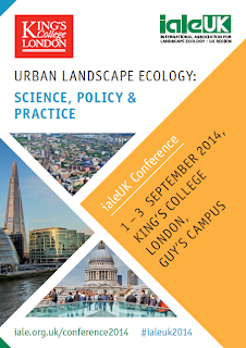
The theme of the conference this year is ‘Urban landscape ecology: science, policy and practice’. We are keen to hear from researchers, policymakers, and practitioners developing new evidence, policies, strategies, plans or projects on the ground that relate to the landscape ecology of urban and peri-urban areas. The call for abstracts has just gone out; please submit abstracts (300 words) for presentations and posters to conference2014@iale.org.uk by 28 February 2014. We expect selected papers will compose an edited volume on current key issues in urban landscape ecology. The full call for abstracts is copied below.
We’ll be updating the conference website regularly throughout the year as conference planning continues, so keep checking back at: http://iale.org.uk/conference2014 Further details of the conference programme and how to register will be available there soon. We’ll be using the hashtag #ialeuk2014 so please use this on social media. And any questions or queries, don’t hesitate to get in touch via conference2014@iale.org.uk
—————————————————-
Call for Abstracts – Urban landscape ecology: Science, policy and practice
Cities are growing rapidly. Across Europe, more than 70 per cent of people already live in urban areas, including 80 per cent of the UK population. The growth of cities poses ever-increasing challenges for the natural environment on which they impact and depend, not only within their boundaries but also in surrounding peri-urban areas. Landscape ecology – the study of interactions across space and time between the structure and function of physical, biological and cultural components of landscapes – has a pivotal role to play in identifying sustainable solutions.
This conference will consider how concepts from landscape ecology can inform the maintenance and restoration of healthy, properly functioning natural environments across urban and peri-urban landscapes, as the foundation of sustained economic growth, prospering communities and personal wellbeing.
Conference themes are likely to include: ecological connectivity of terrestrial and aquatic environments; ecosystem services, including regulation of air quality, urban heat, and water quality and quantity, as well as cultural services; planning for change; and landscape-scale management of terrestrial and aquatic ecosystems.
We are keen to hear from researchers, policymakers, and practitioners developing new evidence, policies, strategies, plans or projects on the ground that relate to the landscape ecology of urban and peri-urban areas.
Please submit abstracts (300 words) for presentations and posters to conference2014@iale.org.uk by 28 February 2014. Selected papers will compose an edited volume on current key issues in urban landscape ecology.
There will be two days of presentations on science, policy, planning and practice, networking events and workshops. We are hoping that fieldtrips on the final day will include visits to the Thames Barrier and surrounding area and to the top of the Shard, Western Europe’s tallest building, from where we can consider connectivity across London and beyond.
Further details of the conference programme and how to register will be available soon.
General enquiries: conference2014@iale.org.uk
Website: http://iale.org.uk/conference2014
Social media: #ialeuk2014
When is a pattern a pattern?
This week I received my copy of ‘Patterns of Land Degradation in Drylands: Understanding Self-Organised Ecogeomorphic Systems’ which I contributed to after participating at a workshop in Potsdam, Germany. It’s a well produced book and as I was flicking through it I came across one of the pieces I wrote. Rather than just leave it hidden away on pages 60 – 61 in the book I thought I’d reproduce it here. It’s less than 500 words and to the point. Just right for a blog post.
“In science, patterns are observations of any non-random structure. In ecology for example, a pattern has long been understood as the “structure which results from the distributions of organisms in, or from, their interactions with their environments” (Hutchinson 1953, p.3, also see Watt 1947, Greig-Smith 1979). However, when identifying patterns in nature, scientists more precisely mean the identification of patterns in data about nature. Important considerations for identifying patterns, therefore, are the means by which data were collected, and most importantly the scales of measurement used to collect data. In particular, two components of scale – grain and extent – are important in determining whether a pattern is identified. Grain is the resolution of measurement (i.e. the smallest unit of measurement at which objects or states can be distinguished), whereas extent is the full scope of observation or total range over which measurements are made. As examples, different spatial patterns will be detectable in maps of vegetation configuration in semi-arid areas depending on the grain and extent of the maps (e.g. compare Figures 3 and 6 in Barbier et al. 2006), and different temporal patterns will be detectable in storm hydrographs depending on the resolution and duration of measurement (e.g. compare drainage for 10 minute intervals with full 80 minute duration, and observed drainage with simulated drainage, in Figure 5 of Mueller et al. 2007). In other circumstances, observed structures may be described as being ‘scale-free’. These structures lack a characteristic length scale and have the same properties across any grain and extent of measurement (e.g. power-law distributions of vegetation patch sizes; Kéfi et al. 2007). These scale-free structures can also be considered to be patterns.
Because patterns are non-random, they have the potential to provide information. In natural science this information is usually understood as being about the processes that caused the pattern. Thus, identifying patterns is useful because they can be used to investigate processes (Levin 1992). Processes are typically assumed to act at a different scale from the patterns they produce, with patterns either emerging from processes at smaller scales (‘bottom-up’ processes) or imposed by constraints at larger scales (‘top-down’ processes). It is also important to consider the reciprocal effects of patterns on processes (Turner 1989). For example, the field of landscape ecology has placed an emphasis on the quantification of spatial pattern using pattern metrics (e.g. McGarigal 2006) and shown how the history of previous ecological processes can increase the strength and extent of spatial pattern (Peterson 2002). The ‘pattern-oriented modelling’ (POM) approach has been developed to use models to help decode the information present in patterns to better understand processes (Wiegand et al. 2003, Grimm et al. 2005). The POM approach iteratively compares empirical and model-output patterns at multiple scales and levels of organization and for multiple models to identify most appropriate models. Approaches like POM, which place pattern at the centre of scientific investigation, are vital for improving understanding about physical processes.”
References
- Barbier N, Couteron P, Lejoly J et al (2006) Self-organized vegetation patterning as a fingerprint of climate and human impact on semi-arid ecosystems. J of Ecol 94:537-547
Greig-Smith P (1979) Pattern in vegetation. J of Ecol 67: 755-779 - Grimm V, Revilla E, Berger U et al. (2005) Pattern-oriented modeling of agent-based complex systems: Lessons from ecology. Science 310:987-991
- Hutchinson GE (1953) The concept of pattern in ecology. Proc of the Acad of Nat Sci of Philadelphia 105:1-12
- Kéfi S, Rietkerk M, Alados, CL et al (2007) Spatial vegetation patterns and imminent desertification in Mediterranean arid ecosystems. Nature 449:213-217
- Levin SA (1992) The problem of pattern and scale in ecology: The Robert H. MacArthur award lecture. Ecology 73(6):1943-1967
- McGarigal K (2006) Landscape pattern metrics. In: El-Shaarawi AH and Piegorsch WW (eds) Encyclopedia of Environmetrics. Wiley: Chichester, UK
- Mueller EN, Wainright J, Parsons, AJ (2007) Impact of connectivity on the modeling of overland flow within semiarid shrubland environments. Water Res Res 43:W09412
- Peterson GD (2002) Contagious disturbance, ecological memory, and the emergence of landscape pattern. Ecosystems 5:329-338
- Turner MG (1989) Landscape ecology: The effect of pattern on process. Ann Rev of Ecol and Syst 20:171-197
- Watt, AS (1947) Pattern and process in the plant community. J of Ecol 35:1-22
- Wiegand T, Jeltsch F, Hanski I et al (2003) Using pattern-oriented modeling for revealing hidden information: A key for reconciling ecological theory and application. Oikos 100:209-222
Citation
Jeltsch, F., Millington, J.D.A., et al. (2014) Resilience, self-organization, complexity and pattern formation In: Mueller, E.N., Wainwright, J., Parsons, A.J. and Turnbull, L. (Eds.) Patterns of Land Degradation in Drylands. Springer, pp. 55-84.
Heartwood Forest #kclfield Activities
Just this week our first year undergraduates had their fieldweek, with lots of geography-related activities across London. For the physical geography activities we headed up to Heartwood Forest, the largest new native forest in England (near Sandridge in Hertfordshire). A nice video from last year’s trip is below.
As you can see from the video, currently much of the ‘forest’ looks more like fields than what would be considered forest in Michigan, but the 600,000 trees being planted by volunteers will grow over the coming years to change that. There are three existing ancient woodlands (covering 45 acres) in the entire 858 acre (347 ha) area the Woodland Trust have acquired. Much of this area was previously agricultural land – the planted trees and newly created meadows will connect the existing woodland.
So there’s going to be some big ecological changes over the coming years as landscape changes. To keep track of changes in vegetation and animal populations volunteers from the Herefordshire Natural History Society (HNHS) have set up a monitoring group that regularly collect data on the growth of new trees, plants, mammals, birds and butterflies.
Similarly, some of the activities our first year undergrads undertook were to do ecological surveys of understory and overstory vegetation. Our students also did hillslope surveys and soil moisture monitoring, measured vertical wind speed profiles (to see how wind speed changes with height from the ground), explored the use of helium balloons and thermal cameras to make aerial photographs and other observations, and learned how to use global positioning system (GPS) units. The students seemed to enjoy the day at Heartwood, and the entire fieldweek for that matter, as you can see from their activities on Twitter (we use the #kclfield hastag to associate tweets with our field activities).
Tweets about “#KCLfield”
!function(d,s,id){var js,fjs=d.getElementsByTagName(s)[0],p=/^http:/.test(d.location)?’http’:’https’;if(!d.getElementById(id)){js=d.createElement(s);js.id=id;js.src=p+”://platform.twitter.com/widgets.js”;fjs.parentNode.insertBefore(js,fjs);}}(document,”script”,”twitter-wjs”);
Over the coming years we hope to expand our students’ field activities at Heartwood to our third year undergraduate and taught Master’s students. In particular, we hope that dissertation research by these students will be able to contribute to the efforts of the Heartwood monitoring group, to collect data and investigate questions of ecological interest. For example, to analyse presence/absence data for mammals like woodmice, we might use statistical modelling techniques like those I used to examine neotropical bird populations in Michigan.
It’s going to be very interesting watching and studying the ecological changes as Heartwood really does become a forest over the years. Keep track of the changes by visiting the forest yourself or via the HSNS website, the Heartwood blog and right here on this blog.


