Homogenization of the northern U.S. Great Lakes Forests

An email sitting in my inbox this morning directed me toward an article in the latest issue of Landscape Ecology that directly addresses one of the issues I touched on in Saturday’s post; the ‘Maple-ization’ of the western UP Northern Hardwood forests via selective forest harvest and the resulting feedbacks with whitetailed deer populations.

Lisa Schulte and colleagues examined the regional-scale impacts of human land use in the northern U.S. Great Lakes region. They found an overall loss of forestland, lower forest species diversity, functional diversity, and structural complexity compared to pre-Euro-American settlement forests.

Generally, they found evidence of shifts from evergreen conifer (-27.0%) to deciduous hardwood (+22.8%) species between pre-Euro-American settlement and the present time. Specifically, they found marked increases in Aspen (+12.8%) and Maple (+10.1%) and decreases in Pine (-17.5%) and Hemlock (-11.3%) across the area as a whole. However, increases in northern hardwood species were not uniform, and Beech and Birch have decreased (~4% each).


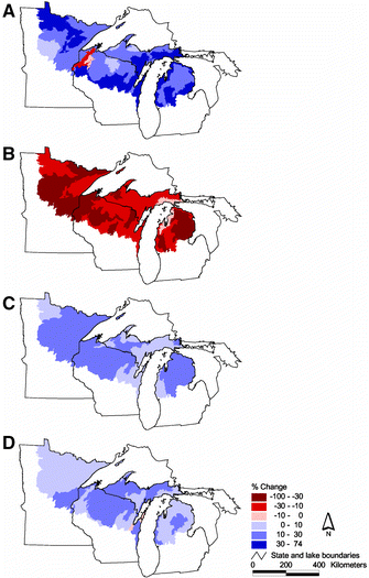
A figure from their paper (above) maps the change in ecoregion characteristics for (A) the extent of open vegetation, (B) dominance of conifers, (C) dominance of aspen (combined Populus tremuloides and P. grandidentata), and (D) dominance of maple (combined Acer saccharum and A. rubrum).

In their discussion the authors (p.1100-01) go on to describe the issues present in our study area;

“Although forests have largely been reestablished across northern portions of the region [following destructive logging in the late 19th century], these forests are on a new trajectory of change rather than recovery toward pre-Euro-American conditions . We attribute lack of recovery to legacies associated with the initial, severe land use conversion, the persistent over-abundance of a keystone herbivore (white-tailed deer), and related management practices that are inattentive to processes that historically promoted vegetation diversity within the region.

The excessive deer abundance at present is a feedback of regional forest management; whitetailed deer at high densities are now regarded as a major threat to forest biodiversity and regeneration in the region and elsewhere (Rooney et al. 2004). The commercial logging that is now the most frequent and widespread forest disturbance across the region largely fails to mimic either the local or landscape effects of the historically prevalent disturbances of windthrow and fire (Mladenoff et al. 1993; Scheller and Mladenoff 2002). Rather, current practices of aspen clearcutting and single-tree selection in maple stands continues to foster this divergence and simplification of the forests by largely favoring their regeneration over a greater diversity of tree species (Crow et al. 2002).”

As I discussed just the other day, we’ll be using the model we’re currently developing to examine spatial scenarios directly related to this issue. For example one aim is to examine scenarios of forest management that allow the recreation of historical herbivore disturbance via spatial patterns of vegetation whilst ensuring the future economic sustainability of the forests.

Reference
Schulte, L.A., Mladenoff, D.J., Crow, T.R., Merrick, L.C., and Cleland, D.T. (2007) Homogenization of northern U.S. Great Lakes forests due to land use Landscape Ecology 22:7 1089-1103

up pics

I’ve just posted some pics from my recent trip to Michigan’s Upper Peninsula on my photos page. Here’s a taster…


Some of the State natural resource manager I met with spoke about the ‘Maple-ization’ of the forests in the western UP – whilst a native of these forests, the economic value of Maple wood is leading to the removal of other Northern Hardwood species and an (over) dominance of Maple.


The Mackinac Bridge, linking the Upper and Lower peninsulas of Michigan, celebrates its 50th birthday this year. Currently the third-longest Suspension Bridge in the world (at 1.7 miles of suspended roadway) it was originally dubbed the ‘Bridge to Nowhere’. Now however, it provides a vital (though recently decreasing) influx of tourist dollars to the UP. Whilst impressive, IMHO the Mackinac Bridge doesn’t have a patch on the Bristolian’s beloved Clifton Suspension Bridge.


Many of those tourists crossing the Mackinac Bridge head to Tahquamenon Falls. The second largest waterfalls east of the Mississippi (after Niagra), at peak flow more than 50,000 gallons of water per second flow over the edge.

Checkout the location of these pics, and others I took on my trip, at the photos page.

Usefulness of Spatial Landscape Models

Turner et al.’s discussion about the usefulness of spatial models in land management is now a bit of a classic (written in 1995) but it had also been a while since I read it. Re-reading it after coming back from a trip to our study area, many of the paper’s points resonated with what people (many of them natural resource managers) I met with were saying.

Turner et al. suggest that (p.13) “Models that integrate ecological and economic components so that the models can be used to explore both sets of consequences simultaneously are even more valuable [than ecological alone]”. This is the driving rationale for our research project. As it was succinctly put by one potential landowner in the study area, models of this kind will contribute to the development of plans that are based on an ecological approach but backed up with economic justification.

Given the hierarchical nature of landscape ecological processes and the importance of human activity on those processes, Turner et al. highlight (p.15) that “Land ownership has a large impact on management decisions, and a useful contribution of spatially explicit models is the ability to explore the effects of management by various owners within a mosaic of public and private lands.” With a range land owners, including the state and private industrial companies, the UP study area is in this position and the model we are developing will be able to directly consider the impacts of different land owner management strategies for the landscape as a wider region. Thus, one of the driving questions of the research is “how should timber be harvested across space and time in multiple land ownerships to ensure a sustainable landscape?”

One of the most striking things I was told on my trip was that the most useful thing our model would be able to do for land managers would be if it could get people to sit down together to come up with a coherent, sustainable management plan. Again, the links with Turner et al. are clear (p.15); “Communication between land managers and ecologists remains an important challenge, and spatially explicit models have the potential to create a common working framework.”

However, not only is the communication and collaboration side of the research a challenge, but so too is the technical side of things. Turner et al. highlight the issue of data quality; the model will only be as good as the data used and the accurate up-to-date spatial data bases required are expensive to produce. Furthermore, the quality of the data will determine the modeller’s ability to parameterizes the model at a given spatial resolution and extent. I’m currently reviewing the data that has been collected over the past few years by the research group at CSIS regarding the interactions between deer density, tree regeneration and bid habitat, but also the data managed and made available by Michigan’s Department of Natural Resources. Producing an accurate representation of deer population dynamics and movement across the landscape is certainly going to be a challenge. Next, the relationships between deer browse pressure and vegetation regeneration need to be specified and parameterized. The estimates of deer population and location can then be combined with these relationships to dynamically represent the interactions across space.

Once the model is up and running we will be able to examine spatial scenarios of forest management to assess both ecological and economic sustainability. For example, with regard to the appropriate location of mesic confer regeneration “…increasing the [mesic confer] component is expected to increase the number of individuals of conifer-associated bird species. And over time reduce productivity of the summer deer range and expand areas potentially suitable for deer during winter, resulting in a smaller deer herd dispersed over a larger wintering area (Doepker et al, 2001) in turn resulting in less browsing pressure in WUP forests. The eventual size, configuration, contiguousness and/or juxtaposition of restored habitats to existing or historical mesic conifer habitats and winter deer-yards on non-MDNR lands (public and private) may affect the success of these outcomes” (DNR 2004). Right now this confer regeneration is not going well and areas of maple forest are increasing.

Economically, the model should be able to show how different harvest rotations and management plans by private industrial land owners can ensure the most productive use of their land whilst ensuring both ecological and economic sustainability of the landscape. And not only for single landowners. The model should be useful to examine how actions of neighbouring land under differing ownership can work in concert. For example, if the private industrial goal is intensive harvest, maybe the primary objective of the state should be to ensure conifer cover. But the question then is what are the spatial implications of this? Is there any point in confer regeneration (which provides thermal cover for deer in the winter) if the distance between state and corporate land is large and deer cannot move from thermal cover to find food?

These are the sorts of questions and challenges to which spatial landscape models can be applied, and which we are aiming to tackle. Right now though, it’s time to concentrate on the technical development of the model and the representation of the spatio-temporal deer-vegetation interactions.

Reference
Turner, M.G., Arthaud, G.J., Engstrom, R.T, Hejl, S.J., Liu, J., Loeb, S. & McKelvey, K. (1995) Usefulness of Spatially Explicit Population Models in Land Management Ecological Applications, 5:1 12-16.

US-IALE 2008 – Call for Symposium Proposals

United States Regional Association of the International Association for Landscape Ecology (US-IALE) 23rd Annual Symposium
April 6-10, 2008
Madison, Wisconsin
Landscape Patterns and Ecosystem Processes

Call for Symposium Proposals
Proposals for symposia will be accepted at any time before September 7. If you are interested in submitting a proposal, please contact the Program Chair, Sarah Goslee. The proposal should include a symposium title, objective, a list of speakers and titles in the order in which you wish them to occur, and the length of each talk (including questions). Talks in symposia need not be the standard 20-minute length, but we ask that you arrange your schedule so that there is a transition on the hour. Please send your proposal to ialeProgram@gmail.com with the subject line “Symposium Proposal”. Once the symposium s accepted, each speakers will be required to submit an abstract following the procedure for regular abstracts (which will be due November 2).

This year we will also accept symposium proposals which include time for relevant talks drawn from the pool of regular submissions. These additional talks will be chosen by the Program Committee with the approval of the symposium organizer. Please note in your proposal whether you are willing to include additional presentations.

All presenters, whether presenting in a symposium, oral or poster session, must register by the early registration deadline or their presentations may be dropped from the program. The early registration deadline will be March 6, 2008. Acceptance letters will be sent out no later than the end of December to allow for plenty of time to meet this requirement. Please contact the Program Chair at ialeProgram@gmail.com with any questions.

Further information at the 2008 US-IALE Annual Symposium homepage

Call for submissions to Oekologie August 2007

I’m a little behind but there’s still no harm in advertising that Oekologie #7 is up at The Evangelical Ecologist.

Oekologie #8 will be hosted right here on Direction not Destination in mid-August. Submit your recent writings on ecology and environmental science here. Here’s the details of what we’re looking for from the Oekologie home page:

Oekologie is a blog carnival all about interactions between organisms in a system. While Circus of the Spineless might look for a post discussing the hunting techniques of a trap door spider, Oekologie is looking for posts discussing how a trap door spider’s hunting techniques affect prey populations or its surroundings. While Carnival of the Green might look for a post discussing a big oil policy decision regarding ANWR, Oekologie would accept a post describing the ecological consequences of pipeline construction in the area.

Again, we are looking for posts describing biological interactions – human or nonhuman – with the environment.

Topics may include but are not limited to posts about population genetics, niche/neutral theory, sustainabilty, pollution, climate change, disturbance, exploitation, mutualism, ecosystem structure and composition, molecular ecology, evolutionary ecology, energy usage (by humans or within biological systems, succession, landscape ecology, nutrient cycling, biodiversity, agriculture, waste management, etc. The list goes on and on; I think you get the idea.

Your blog does not have to be an ecology or environmental blog itself, but the post should present an accurate representation of the field.

The post should be spell-checked, grammatically sound, and substantial; we’re not looking for brief reviews. If you are reviewing research, please include solid commentary involving other sources.

Summary – Validating and Interpreting Socio-Ecological Simulation Models

So finally the summary to my set of posts about the validation and interpretation of Socio-Ecological Simulation Models (SESMs)that arose out of some of the thinking I did during my PhD thesis.

The nature of open systems requires SESMs to specify and place boundaries on the system such that it may analysed effectively. Recent debate in the geographical and environmental modelling communities has highlighted the importance of observer dependencies when identifying the appropriate model ‘closure’. Furthermore, because an ‘open’ system can be ‘closed’ for study in multiple ways whilst still adequately representing system behaviour, the issue of model ‘affirming the consequent’ is present when attempting to model these systems.

Because of these issues I suggested that a more reflexive approach, emphasising trust via practical adequacy over the establishment of true model structure via mimetic accuracy, will put SESMs in a better position to provide understanding for non-modellers and contribute more readily to the decisions and debates regarding contemporary problems facing many real world environmental systems.

This is not to say issues regarding mimetic accuracy and model structure should be totally ignored – these model validation criteria will still have a role to play. However, emphasising trust via practical adequacy over truth via mimetic accuracy, ensures the model validation question is ‘how good it this model for my purposes?’ and not ‘is this model true?’. Engagement with local stakeholders throughout the modelling processes, contributing to model development and application should ensure practical adequacy, but also, in parallel, trust. As a result of this participatory model evaluation exercise, confidence in the model should be built, hopefully to the level where it can be deemed to be ‘validated’ (i.e. fit for purpose).

Ecological Approach, Economic Justification

This last week I have been touring around our study area and its wider landscape setting in Michigan’s Upper Peninsula. As well as spending a couple of days in the forest ‘helping out’ with some empirical fieldwork being done by MSc student Megan Metonis on the relationship between northern hardwood forest regeneration, timber harvest gap size, and deer browse, I’ve been talking with local managers from the Department of Natural Resources and other management stakeholders.

Whilst I’ll write more about my trip once I’m back at MSU, one of the key things the DNR indicated they would hope our modelling project might achieve is the improved collaboration of multiple land owners and stakeholders, each with their own priorities and expectations, to build the beginnings of a long-term forestry management plan. Such long-term planning has been virtually non-existent in the past, but it was interesting to see an article in a UP newspaper describing the meeting of corporate land owners, natural resource managers and university academics to discuss future land use, ownership and economic trends. This meeting gives me some hope that improved collaboration for forestry management in this area isn’t impossible. If this is the case, as one potential future land owner suggested, the use of the model we’re developing could help develop plans that are based on an ecological approach but backed up with economic justification.

UP Fieldwork

I’m heading off to the UP later today to visit our study area for the first time. I’m looking forward to actually seeing place we’re going to be modelling and to get a better intuitive understanding about how the system works and what the issues are. Whilst I’m up there I plan on helping out with some ongoing MSU Northern Hardwood seedling experiments and meeting with people involved in the use and management of the region at organisations such as Michigan’s Department of Natural Resources, the Hiawatha National Forest, The Nature Conservancy, and the Hannahville Indian Community. I’ll be offline whilst I’m away – I’ll let you know how it went when I’m back.

Stakeholder Participation and Expertise

The problems of equifinality and affirming the consequent suggest alternative criteria by which to validate or evaluate socio-ecological simulation models (SESMs) will be useful. In my last post in this series I suggested that trust and practical adequacy might be useful additional criteria. In light of the ‘risk society’-type problems facing the systems that SESMs represent, and the proposed post-normal science approaches to examine and resolve them, the participation of local stakeholders in the model validation process seems an important and useful approach to ensure and improve model quality. If local stakeholders are to accept decisions and policies made based upon results from simulation models they will need to trust a model and, by consequence, the modeller(s).

Due to a perceived ‘crisis of trust’ in science over the last 20 years, Wilsdon and Willis suggest “scientists have been slowly inching their way towards involving the public in their work” and that we are now on the cusp of a new phase of public engagement that takes it ‘upstream’. This widely used, but somewhat vague term, is used to refer to the early involvement of the lay public in the processes of scientific investigation. As such, engagement is ‘upstream’ nearer the point at which the research and development agenda is set, as opposed to the ‘downstream’ end at which research results are applied and the consequences examined (see Figure 1).

Figure 1 Public participation in the scientific research process. Recently it has been suggested that public engagement with the scientific process needs to move ‘upstream’ nearer the point at which the research agenda is set. After Jackson et al

Whereas previously the theory of the ‘public understanding of science’ was a deficit model suggesting that the public would trust science ‘if only they understood it’, the contemporary shift is towards and engagement and dialogue between science and society. The implication of this new turn is that the public will trust science ‘if only they are involved in the process itself’. Recently, Lane et al. advocated this move upstream for forms of environmental modelling that address issues and concerns of rural populations. This position has been criticised as devaluing the worth of science, for patronising the public, and being a mask for political face-saving or insurance.

Regardless of other areas of science, in the case of developing simulation models for socio-ecological systems the participation of the public does not result in the first two of these criticisms. Engaging with local stakeholders to ensure a model is both built on a logically and factually coherent foundation and to ensure it examines the appropriate questions and scenarios is of great value to the modelling process and should improve representation of the empirical system. Contributing to successful iterations of this process, local stakeholders will gain both trust and understanding. However, the inclusion of local stakeholders in the modelling process does raise the issue of expertise.

With parallels in the three phases Wilsdon and Willis have suggested, Collins and Evans have suggested we are entering a third wave in the sociology of science. This third wave demands a shift from an emphasis on technical decision-making and truth to expertise and experience. Collins and Evans suggest there are three types of expert in technical decision-making (i.e. decision-making at the intersection of science and politics); ‘No Expertise’, ‘Interactional Expertise’, and ‘Contributory Expertise’.

Individuals possessing interactional expertise are able to interact ‘interestingly’ with individuals undertaking the science, but not to contribute to the activities of science itself (contributory expertise). Brian Wynne’s well-known study of the (inadequate) interaction between Cumbrian sheep farmers and UK government scientists investigating the ecological impacts of the Chernobyl disaster is a prime example of a situation in which two parties possessed contributory expertise, but neither interactional expertise. As a result, the ‘certified’ expertise of the government scientists was given vastly more weight than the ‘non-certified’ expertise of the farmers (to the detriment of the accuracy of knowledge produced). Such non-certified expertise might also be termed ‘experience-based’ expertise, arising as it does from the day-to-day experiences of particular individuals.

The importance of considering non-certified, contributory experience is particularly acute for SESMs. Specifically, local stakeholders are likely to be an important, if not the primary, source of knowledge and understanding regarding socio-economic processes and decision-making within the study area. Furthermore, the particular nature of the interactions between human activity and ecological (and other biophysical) processes within the study area will be best understood and incorporated into the simulation model via engagement with stakeholders. This local knowledge will be vital to ensure the logical and factual foundations of the model are as sound as possible.

Furthermore, engagement with local stakeholders will highlight model omissions, areas for improved representation, and guide application of the model. It provides an opportunity to enlighten experts as to the ‘blind spots’ in their knowledge and questions. As such, the local stakeholders become an ‘extended peer community’, lending alternative forms of knowledge and expertise to the model (and research) validation process than that of the scientific peer community. This knowledge and expertise may be less technical and objective than that of the scientific community, but this nature does not necessarily reduce its relevance or utility to the modelling of a system that contains human values and subjects.

I pursued this idea of stakeholder participation in the modelling I undertook for my PhD. Early in the development of my agent-based model of land use decision-making, local stakeholders were interviewed with regards to how they made decisions and their understanding about landscape dynamics. Upon completion of model construction I went to talk with stakeholders about the model as they offered the prime source of criticism about the model representation of their decision-making activities. By engaging with these stakeholders a form of qualitative, reflexive model validation was performed that overcame some of the problems of a more deductive approach.

BSG – Modelling Human Impacts on Geomorphic Processes

This week sees the Annual Conference of the British Society for Geomorphology (BSG – formerly the British Geomorphological Research Group, BGRG). Running from Wednesday 4th to Friday 6th, the conference is being held at the University of Birmingham in the UK. With the theme Geomorphology: A 2020 Vision, recent developments and advances in the field, such as models and modelling approaches, will be explored and debated, and the potential to exploit emerging approaches to solve key challenges throughout pure and applied Geomorphology will be discussed.

With these recent and future advances in mind, one of my PhD advisors, Prof. John Wainwright, will present a paper entitled Modelling Human Impacts on Geomorphic Processes which contains work originating from my thesis. He’ll be presenting it in the first session of Wednesday afternoon, Process Modelling: Cross-Cutting Session. I’m sure it will turn out to be an interesting session, and one that continues the recent thirst for inter- and cross-disciplinary research. Here’s the abstract:

Modelling Human Impacts on Geomorphic Processes
John Wainwright and James Millington

Despite the recognition that human impacts play a strong – if not now predominant – rôle in vegetation and landscape evolution, there has been little work to date to integrate these effects into geomorphic models. This inertia has been the result partly of philosophical considerations and partly due to practical issues.

We consider different ways of integrating human behaviour into numerical models and their limitations, drawing on existing work in artificial intelligence. Practical computing issues have typically meant that most work has been very simplistic. The difficulty of estimating time-varying human impacts has commonly led to the use of relatively basic scenario-based models, particularly over the longer term. Scenario-based approaches suffer from two major problems. They are typically static, so that there is no feedback between the impact and its consequences, even though the latter might often lead to major behavioural modifications. Secondly, there is an element of circularity in the arguments used to generate scenarios for understanding past landform change, in that changes are known to have happened, so that scenarios big enough to produce them are often generated without considering the range of possible alternatives.

In this paper we take examples from two systems operating in different contexts and timescales, but employing a similar overall approach. First, we consider human occupations in prehistoric Europe, in particular in relation to the transition from hunter-gatherer to simple agricultural strategies. The consequences of this transition for patterns of soil erosion are investigated. Secondly, an example from modern Spain will be used to evaluate the effects of farmers’ decision-making processes on land use and vegetation cover, with subsequent impacts on fire régime. From these agent-based models and from other examples in the literature, conclusions will be drawn as to future progress in developing these models, especially in relation to model definition, parameterization and testing.