A joint seminar between the Royal Bath and West of England Society and RGS with IBG, “with the aim of examining some of the problems and solutions relating to planning for future sustainable land use in rural areas. Using the West Country as a model, eminent speakers will cover such topics as climate change, population increase, pollution concerns, security of food, energy and economy, biodiversity and scientific developments.”
Tag: Landscapes
Arizona’s Ancient Landscape
My landscape interests usually focus on contemporary, biological issues like forest dynamics and human activity. But driving through Arizona’s desert it’s hard not to be impressed by landscape features shaped over geological time scales.
The ancient trees of Petrified Forest National Monument – preserved as quartz crystal moulds of trees buried by sediments before they decomposed – are over 200 million years old.
At that time, in the Late Triassic, northeastern Arizona was located near the equator resulting in a tropical climate and vegetation. The climate and landscape couldn’t be much more different now and the sheer scale of change (both time and location) are hard to comprehend looking out over the desert sunset.
The physical size of the Grand Canyon isn’t much easier to comprehend, even when you’re stood at the very edge of the southern rim.
By the time the Colorado river had begun carving the canyon a mere 17 million years ago, the processes leading to its formation had already been at work for around 2,000 million years (the lowest sediments at the bottom of the Inner Gorge date to around that time). Sunset here is no less timeless than in the Petrified Forest.
Compared with the forest and the gorge the Barringer Crater was created in the blink of an eye. But the 300,000 ton meteor that hit earth 50,000 years ago had probably being travelling on that collision course for a much longer time.
That these awesome features remain – so huge in time and space – reminds us how fleeting our biological landscapes are.
Disturbance and Landscape Dynamics in a Changing World
Experimentation can be tricky for landscape ecologists, especially if we’re considering landscapes at the human scale (it’s a bit easier at the beetle scale [pdf]). The logistic constraints of studies at large spatial and temporal scales mean we frequently use models and modelling. However, every-now-and-then certain events afford us the opportunity for a ‘natural experiment’ – situations that are not controlled by an experimenter but approximate controlled experimental conditions. In her opening plenary at ESA 2009, Prof. Monica Turner used one such natural experiment – the Yellowstone fires of 1988 – as an exemple to discuss how disturbance affects landscape dynamics and ecosystem processes. Although this is a great example for landscapes with limited human activity, it is not such a useful tool for considering human-dominated landscapes.
Landsat satellite image of the Yellowstone fires on 23rd August 1988. The image is approximately 50 miles (80 km) across and shows light from the green, short-wave infrared, and near infrared bands of the spectrum. The fires glow bright pink, recently burned land is dark red, and smoke is light blue.
Before getting into the details, one of the first things Turner did was to define disturbance (drawing largely on Pickett and White) and an idea that she views as critical to landscape dynamics – the shifting mosaic steady state. The shifting mosaic steady state, as described by Borman and Likens, is a product of the processes of vegetation disturbance and succession. Although these processes mean that vegetation will change through time at individual points, when measured over a larger area the proportion of the landscape in each seral stage (of succession) remains relatively constant. Consequently, over large areas and long time intervals the landscape can be considered to be in equilibrium (but this isn’t necessarily always the case).
Other key ideas Turner emphasised were:
- disturbance is a key component in ecosystems across many scales,
- disturbance regimes are changing rapidly but the effects are difficult to predict,
- disturbance and heterogeneity have reciprocal effects.
Landscape Dynamics
In contrast to what you might expect, very large disturbances generally increase landscape heterogeneity. For example, the 1988 Yellowstone fires burned 1/3 of the park in all forest types and ages but burn severity varied spatially. Turner highlighted that environmental thresholds may determine whether landscape pattern constrains fire spread. For instance, in very dry years spatial pattern will likely have less effect than years where rainfall has produced greater spatial variation in fuel conditions.
Turner and her colleagues have also found that burn severity, patch size and geographic location affected early succession in the years following the Yellowstone fires. Lodgepole pine regeneration varied enormously across the burned landscape because of the spatial variation in serotiny and burn severity. Subsequently, the size, shape and configuration of disturbed patches influenced succession trajectories. Turner also highlighted that succession is generally more predictable in small patches, when disturbances are infrequent, and when disturbance severity/intensity is low (and vice versa).
Ecosystem Processes
One of the questions landscape ecologists have been using the Yellowstone fires to examine is; do post-disturbance patterns affect ecosystem processes? Net Primary Production varies a lot with tree density (e.g., density of lodgepole pine following fire) and the post-fire patterns of tree density have produced a landscape mosaic of ecosystem process rates. For example, Kashian and colleagues found spatial legacy effects of the post-fire mosaic can last for centuries. Furthermore, this spatial variation in ecosystem process rates is greater than temporal variation and the fires produced a mosaic of different functional trajectories (a ‘functional mosaic’).
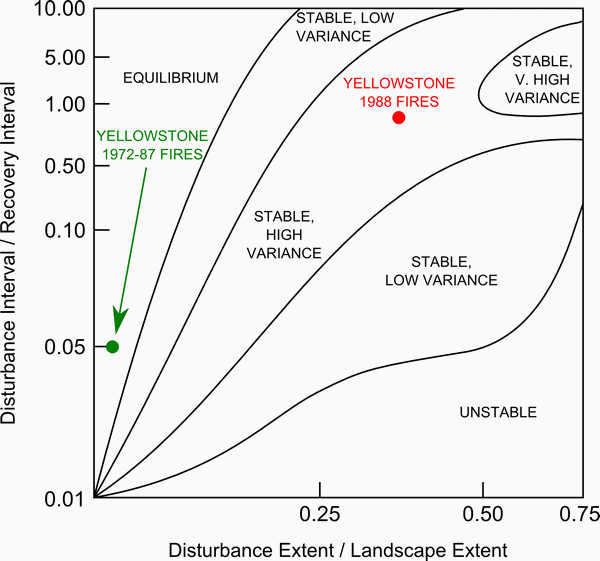
Another point Turner was keen to make was that the Yellowstone fires were not the result of fire suppression as is commonly attributed, but instead they were driven by climate (particularly hot and dry conditions). Later in the presentation she used the ecosystem process examples above to argue that the Yellowstone fires were not an ecological disaster and that the ecosystem has proven resilient. However, she stressed that fire will continue to be an important disturbance and that the fire regimes is likely to change rapidly if climate does. For example, Turner highlighted the study by Westerling and colleagues that showed that increased fire activity in the western US in recent decades is a result of increasing temperatures, earlier spring snowmelt and subsequent increases in vegetation moisture deficit. If climate change projections of warming are realised, by 2100 the climate of 1988 (which was extreme) could become the norm and events like the Yellowstone fires will be much more frequent. For example, using a spatio-temporal state-space diagram (seebelow), Turner and colleagues [pdf] found that fires in Yellowstone during the 15 years previous to 1988 had relatively little impact on landscape dynamics (shown in green in the lower left of the diagram). However, the extent of the 1988 fires pushed the disturbance regime up into an area of the state-space not characteristic of a shifting-mosaic steady state (shown in red).
The spatio-temporal state-space diagram used by Turner and colleagues [pdf] to describe potential landscape disturbance dynamics. On the horizontal x-axis is the ratio of disturbance extent (area) to the landscape area and on the vertical y-axis is the ratio of disturbance interval (time) to recovery interval. Landscapes in the upper left of the diagram will appear to an observer as relatively constant in time with little disturbance impact; those in the lower right are dominated by disturbance.
Remaining Questions
Turner finished her presentation by highlighting what she sees as key questions for studying disturbance and landscape dynamics in a changing world:
- How will disturbance interact with one another?
- How will disturbances interact with other drivers?
- What conditions will cause qualitative shifts in disturbance regimes (like that shown in the diagram above)?
It was comforting to hear that a leader in the field identified these points as important as many of them relate closely to what I’ve been working on thinking about. For example, the integrated ecological-economic forest modelling project I’m working on here in Michigan explicitly considers the interaction of two disturbances – human timber harvest and deer herbivory. The work I initiated during my PhD relates to the second question – how does human land use/cover change interact and drive changes in the wildfire regime of a landscape in central Spain? And recently, I reviewed a new book on threshold modelling in ecological restoration for Landscape Ecology.
Much of Turner’s presentation and discussion applied to American landscapes with limited human activity. This not surprising of course, given the context of the presentation (at the Ecological Society of America) and the location of her study areas (all in the USA). But although natural experiments like the 1988 Yellowstone fires may be useful as an analogue to understand processes and dynamics in similar systems, it is also interesting (and important) to think about how other systems potentially differ from this examplar. For example, the Yellowstone fires natural experiment has little to say about disturbance in human-dominated landscapes that are prevalent in many areas of the world (such as the Mediterranean Basin). In the future, research and models of landscape succession-disturbance dynamics will need to focus as much attention on human drivers of change as environmental drivers.
Turner concluded her plenary by emphasising that ecologists must increase their efforts to understand and anticipate the effects of changing disturbance regimes. This is important not only in the context of climate as driver of change, but also because of the influence of a growing human population.
ESA 2009 Abstract
February 2009 seems to be the month of abstracts. Here’s another we just submitted to the 94th Ecological Society of America Annual Meeting, the theme of which is Ecological Knowledge and a Global Sustainable Society.
Local winter white-tailed deer density: Effects of forest cover pattern, stand structure, and snow in a managed forest landscape
James D. A. Millington, Michael B. Walters, Megan S. Matonis and Jianguo Liu
Michigan State University
Background/Question/Methods
White-tailed deer (Odocoileus virginianus) are a ‘keystone herbivore’ with the potential to cause tree regeneration failure and greatly affect vegetation dynamics, stand structure and ecological function of forests across eastern North America. In northern mixed conifer-hardwood forests, local winter-time deer populations are dependent on habitat characterized by patterns of forest cover that provide shelter from snow and cold temperatures (lowland conifer stands) in close proximity to winter food (deciduous hardwood stands). Stand structure may also influence winter spatial deer distribution. Consequently, modification of forest cover patterns and stand structure by timber harvesting may affect local spatial deer distributions, with potential ecological and economic consequences. Here, we ask if forest cover pattern and stand structure, and their interactions with snow depth, can explain winter deer density in the managed forests of the central Upper Peninsula of Michigan, USA. For each local winter deer density estimate (from fecal pellet counts) we calculate stand-level characteristics for surrounding ‘landscapes of influence’ of radius 200 m and 380 m. For these data, and modeled snow depth estimates, we use multivariate techniques to produce predictive models and to identify the most important factors driving local deer densities across our 400,000 ha study area.
Results/Conclusions
Distance to the nearest conifer stand consistently explains the most variance in univariate regression models. Deer densities are highest near lowland conifer stands in areas where the proportion of hardwood forest-cover is high but the mean tree diameter-at-breast-height is low. Multiple regression models including these factors explain up to 38% of variance in deer density and have up to a 68% chance of correctly ranking a site’s deer density (relative to other sites within our study area). We are unable to conclusively show that snow depth has a significant impact on winter deer density, but our data suggest that more detailed investigation into the combined effect of distance to lowland conifer and snow depth may prove fruitful. Our results quantify clear effects of stand structure and forest cover composition on the winter spatial distribution of white-tailed deer. We briefly discuss how these results can be used in an ecological-economic simulation model of a managed forest for tree regeneration risk assessment. Use of these results, and the simulation model, will help identify management practices that can decrease deer impacts and ensure the ecological and economic sustainability of forests in which deer browse is proving problematic for tree regeneration.
Seeds and Quadtrees
The main reason I haven’t blogged much recently is because all my spare time has been taken up working on revisions to a paper submitted to Environmental Modelling and Software. Provisionally entitled ‘Modelling Mediterranean Landscape Succession-Disturbance Dynamics: A Landscape Fire-Succession Model’, the paper describes the biophysical component of the coupled human-natural systems model I started developing during my PhD studies. This biophysical component is a vegetation state-and-transition model combined with a cellular-automata to represent wildfire ignition and spread.
The reviewers of the paper wanted to see some changes to the seed dispersal mechanism in the model. Greene et al. compared three commonly used empirical seed dispersal functions and concluded that the log-normal distribution is generally the most suitable approximation to observed seed dispersal curves. However, dispersal functions using an exponential function have also been used. A good example is the LANDIS forest landscape simulation model that calculates the probability of seed fall (P) in a region between the effective (ED) and maximum (MD) seed distance from the seed source. For distances from the seed source (x) < ED, P = 0.95. For x > MD, P = 0.001. For all other distances P is calculated using the negative exponential distribution function is used as follows:where b is a shape parameter.
Recently Syphard et al. modified LANDIS for use in the Mediterranean Type Environment of California. The two predominant pine species in our study area in the Mediterran Basin have different seed types: one (Pinus pinaster) has has wings and can fly large distances (~1km), but the other (Pinus pinea) does not. In this case a negative exponential distribution is most appropriate. However, research on the dispersal of acorns (from Quercus ilex) found that the distance distribution of acorns was best modeled by a log-normal distribution. I am currently experimenting with these two alternative seed dispersal distributions and comparing them with spatially random seed dispersal (dependent upon quantity but not locations of seed sources).
The main thing that has kept me occupied the last couple of weeks has been the implementation of these approaches in a manner that is computationally feasible. I need to run and test my model over several hundred (annual) timesteps for a landscape grid of data ~1,000,000 pixels. Keeping computation time down so that model execution does not take hundreds of hours is clearly important if sufficient model executions are to be run to ensure some form of statistical testing is possible. A brute-force iteration method was clearly not the best approach.
One of my co-authors suggested I look into the use of Quadtrees. Quadtrees are a tree data structure that are often used to partition a two dimensional space by recursively subdividing regions into quadrants (nodes). A region Quadtree partitions a region of interest into four equal quadrants. Each of these quadrants is subdivided into four subquadrants, each of which is subdivided and so on to the finest level of spatial resolution required. The University of Maryland have a nice Java applet example that helps illustrate the concept.
For our seed dispersal purposes, a region quadtree with n levels of may be used to represent an landscape of 2n × 2n pixels, where each pixel is assigned a value of 0 or 1 depending upon whether it contains a seed source of the given type or not. The distance of all landscape pixels to a seed source can then be quickly calculated using this data structure – staring at the top level we work our way down the tree querying whether each quadrant contains a pixel(s) that is a seed source. In this way, large areas of the grid can be discounted as not containing a seed source, thereby speeding the distance calculation.
Now that I have my QuadTree structure in place model execution time is much reduced and a reasonable number of model executions should be possible over the next month or so of model testing, calibration and use. My next steps are concerned with pinning down the appropriate values for ED and MD in the seed dispersal functions. This process of parameterization will take into account values previously used by similar models in similar situations (e.g. Syphard et al.) and empirical research and data on species found within our study area (e.g. Pons and Pausas). The key thing to keep in mind with these latter studies is their focus on the distribution of individual seeds from individual trees – the spatial resolution of my model is 30m (i.e. each pixel is 30m square). Some translation of values for individuals versus aggregated representation of individuals (in pixels) will likely be required. Hopefully, you’ll see the results in print early next year.
IALE-UK 2008 Conference
The provisional conference programme for the Annual Conference of the UK Regional Association of the International Association for Landscape Ecology (IALE-UK) has been published. The conference will take place between 8th – 11th September 2008 at Cambridge University with sessions to include:
- Conservation in Farmed Landscapes
- Dispersal in Fragmented Landscapes
- Culture and Landscapes
- Distribution and Fragmented Landscapes
- Theory Into Practice: Landscape Ecology Being Used to Conserve Habitats and Species
As with all IALE conferences there will be a field trip that attendees can join. This year the IALE-UK trip will visit the Great Fen Project and Wicken Fen, part of the largest wetland restoration in Europe.
The conference programme is now full, but there are still opportunities to submit posters. Registration to attend also remains open. For submissions and registrations, contact Pete Carey, and for more information visit the conference webpage.
‘Mind, the Gap’ Manuscript
Earlier this week I submitted a manuscript to Earth Surface Processes and Landforms with one of my former PhD advisors, John Wainwright. Provisionally entitled Mind, the Gap in Landscape-Evolution Modelling (we’ll see what the reviewers think of that one!), the manuscript argues that agent-based models (ABMs) are a useful tool for overcoming the limitations of existing, highly empirical approaches in geomorphology. This, we suggest, would be useful because despite an increasing recognition that human activity is currently the dominant force modifying landscapes geomorphically, and that this activity has been increasing through time, there has been little integrative work to evaluate human interactions with geomorphic processes.
In the manuscript we present two case studies of models that consider landscape change with the aid of an ABM – SPASIMv1 (developed during my PhD) and CybErosion (a model to simulate the dynamic interaction of prehistoric communities in Mediterranean environments John has developed). We evaluate the advantages and disadvantages of the ABM approach, and consider some of the major challenges to implementation. These challenges include potential process scale mis-matches, differences in perspective between investigators from different disciplines, and issues regarding model evaluation, analysis and interpretation.
I’ll post more here as the review process progresses. Hopefully progress with ESPL will be a little quicker than it has been for the manuscript I submitted to Environmental Modelling and Software detailing the biophysical component of SPASIMv1 (still yet to receive the review after 5 months!)…
Britain from Above
I like climbing tall things in cities and then looking down to watch the human ants going about their business. Maybe my interest in experimenting with spatial agent-based models is related to this fascination.
The BBC have taken these ideas, of looking down from on high and exploring the dynamic interplay of human activity across space, and produced some incredible movies for a new show. Checkout some of the footage below – looks awesome.
If you’re in the UK, the new series Britain From Above starts at 9pm on Sunday 10th August, BBC One.
US-IALE 2009: Coupling Humans and Complex Ecological Landscapes
Coupling Humans and Complex Ecological Landscapes is the theme of the 2009 annual conference of US-IALE (U.S. Regional Association, International Association for Landscape Ecology). The conference will be held in Snowbird, Utah, from April 12-16, 2009. Proposals for symposia and workshops are due September 15, 2008; and abstracts are due November 17, 2008.
Several types of financial support for attending and presenting at the conference are available:
(1) the “Sponsored Student Travel Awards Program” of local sponsors (USGS, Utah State University, and Utah Department of Natural Resources),
(2) US-IALE’s ‘Foreign Scholar Travel Award‘ Program,
(3) the ‘NASA-MSU Professional Enhancement Awards Program‘ (supported by NASA and Michigan State University), and
(4) the ‘CHANS Fellows Program’ of the new International Network of Research on Coupled Human and Natural Systems (CHANS-Net, supported by NSF, see background papers in Science and Ambio).
US-IALE conferences are particularly students-friendly, with two popular programs — Lunch with Mentors and NASA-MSU dinner, and a new program — We’ll “Pick Up The Tab!”.
More information about the conference is available from the web site.
Effective Modelling for Sustainable Forest Management
In many forest landscapes a desirable management objective is the sustainability of both economic productivity and healthy wildlife populations. Such dual-objective management requires a good understanding of the interactions between the many components and actors at several scales and across large extents. Computer simulation models have been enthusiastically developed by scientists to improve knowledge about the dynamics of forest growth and disturbance (for example by timber harvest or wildfire).
However, Papaik, Sturtevant and Messier write in their recent guest editorial for Ecology and Society that “models are constrained by persistent boundaries between scientific disciplines, and by the scale-specific processes for which they were created”. Consequently, they suggest that:
“A more integrated and flexible modeling framework is required, one that guides the selection of which processes to model, defines the scales at which they are relevant, and carefully integrates them into a cohesive whole”.
This new framework is illustrated by the papers in the Ecology and Society special feature ‘Crossing Scales and Disciplines to Achieve Forest Sustainability: A Framework for Effective Integrated Modeling’.
The papers in the special feature provide case studies that reflect two interacting themes:
- interdisciplinary approaches for sustainable forest landscape management, and
- the importance of scaling issues when integrating socioeconomic and ecological processes in the modeling of managed forest ecosystems.
These issues are well related to the project I’m currently working on that is developing an integrated ecological-economic model of a managed forest landscape in Michigan’s Upper Peninsula. One paper that caught my eye was by Sturtevant et al., entitled ‘A Toolkit Modeling Approach for Sustainable Forest Management Planning: Achieving Balance between Science and Local Needs’.
Sturtevant et al. suggest that forest managers are generally faced with a “devil’s choice” between using generic ‘off-the-shelf models’ where information flows primarily from researchers and planners down to local communities versus developing case-specific models designed for a specific purpose or locale and based on information from the local actors. To avoid this choice, which Sturtevant et al. believe will seldom result in a satisfactory management result, they outline their proposal for a hybrid ‘toolkit’ approach. Their alternative approach “builds on existing and readily adaptable modeling ‘tools’ that have been developed and applied to previous research and planning initiatives”.
Their toolkit approach is
- collaborative – including stakeholders and decision-makers
- a ‘meta-modelling’ approach – the model is derived from other models and tools.
They then illustrate their toolkit approach using a case study from Labrador, Canada, highlighting the stages of establishing the issues, developing a conceptual model, implementing the meta-model, and then refining the model iteratively. They conclude:
“A toolkit approach to SFM [Sustainable Forest Management] analytical support is more about perspectives on information flow than on technical details. Certainly expertise and enabling technology are required to allow a team to apply such a framework. However, the essence of this approach is to seek balance between top-down (off the shelf, science-driven) and bottom-up (case-specific, stakeholder-driven) approaches to SFM decision support. We aim to find a pivot point, with adequate information flow from local experts and stakeholders to scientists, while at the same time avoiding “reinventing the wheel” (e.g. Fig. 1) by making full use of the cumulative experience of scientists and tools they have constructed.”
Although this ‘meta-model’ approach may save time on the technical model building side of things, many resources (time, effort and money) will be required to build and maintain relationships and confidence between scientists, managers and local stakeholders. This approach is really a modelling toolkit for management, with very little emphasis on improving scientific understanding. In this case the modelling is the means to the end of integrative/participatory management of the forest landscape.
The authors continue:
“The mixture of local experts and stakeholders who understand how the tools work, scientists who are willing and able to communicate their science to stakeholders, and integrated analytical tools that can simulate complex spatial and temporal problems will provide powerful and efficient decision support for SFM.”
Unfortunately, unless the scientists in question have the explicit remit to offer their services for management purposes, this sort of modelling approach will not be very appealing to them. In a scientific climate of ‘publish or perish’, management outcomes alone are unlikely to be enough to lure the services of scientists. In some cases I’m sure I will be wrong and scientists will happily oblige. But more generally, unless funding bodies become less concerned with tangible outputs at specific points in time, and academic scientists are judged less strictly by their publishing output, this situation may be difficult to overcome.
This situation is one reason the two sides of the “devils’ choice” are more well developed to the expense of the ‘middle-ground’ toolkit approach. ‘Off-the-shelf’ models, such as LANDIS, are appealing to scientists as they allow the investigation of more abstract and basic science questions than asked by forest managers. The development of ‘customized’ models is appealing to scientists because they allow more detailed investigation of underlying processes and provide a framework for the collection of empirical data collection. No doubt the understanding gained from these approaches will eventually help forest managers – but not in the manner of direct decision-support as the toolkit modelling approach proposes.
As a case in point, the ‘customized’ Managed Forest Landscape Model for Michigan I am working on is raising questions about underlying relationships between deer and forest stand structure. I’m off into the field this week to get data collection started for just that purpose.